Community Access Road Project Update
The intent of our project newsletter is to describe and explain current and ongoing activities being done by the Marten Falls First Nation (MFFN) Community Access Road (CAR) Project Team, and to answer common questions that come up as the environmental assessment (EA) moves forward.
Federal Impact Assessment Update
Since October, the Community Access Road Project Team developed responses to the Summary of Issues received from the Impact Assessment Agency of Canada (IAAC) following the public review periods and, updated to the Initial Project Description with the feedback to form the Detail Project Description (DPD). The Summary of Issues responses and the DPD were submitted to IAAC on the regulatory deadline of November 10, 2019. These two documents are used by IAAC to determine if an impact assessment is required and to develop the tailored impact assessment guidelines.
On November 28, 2019, Marten Falls First Nation received notice that a federal impact assessment is required for the Marten Falls Community Access Road Project. Currently, IAAC is working to develop several documents including:
- Impact Assessment Cooperation Plan – Outlines how the regulatory bodies will coordinate the provincial environmental assessment and the federal impact assessment processes.
- Public Participation Plan – Outlines how IACC will engage the public during the impact assessment.
- Permitting Plan – Outlines all the federal permits that will be required for the project.
- Indigenous Engagement and Partnership Plan – Outlines how IAAC will conduct engagement and consultation with indigenous communities during the impact assessment.
- Tailored Impact Statement Guidelines – Outlines what needs to be studied as part of the impact assessment.
Currently, IAAC is consulting with indigenous communities to seek feedback on:
- Social, health, economic and environmental values important to communities that should be considered in the Tailored Impact Statement Guidelines and,
- How communities want to be engaged and consulted during the impact assessment.
A Draft Indigenous Engagement and Partnership Plan and Draft Tailored Impact Statement Guidelines will be available for a public review and comment period starting on December 18, 2019 and closing on January 28, 2020. It should be noted that IAAC maintains the Duty to Consult and conducts consultation with Indigenous communities.
Federal Consultation Happening Now!
Impact Assessment Agency if Canada (IAAC) has started consulting First Nations on the Marten Falls Community Access Road and the Webequie Supply Road projects.
Currently IAAC is seeking feedback on:
- Impacts to Aboriginal and Treaty Rights
- Important environment, social, health and economic values
- How engagement and consultation should be done during the impact assessment process
IAAC expects First Nations to identify impacts to Aboriginal and Treaty Rights and, important community values.
On December 18, 2019, IAAC will released two documents for public review and comment:
- Draft Tailored Impact Statement Guidelines
- Indigenous Engagement and Partnership Plan
Marten Falls Community Access Road Project Comment periods closes January 28, 2020.
Ask your Chief and Council for more information.
Provincial Individual Environmental Assessment Update
On December 4, 2019, a Draft Terms of Reference (ToR) for the provincial environmental assessment process was released for public review and comment for 45 days. The release of a Draft ToR is not a regulatory requirement and, its purpose is to obtain feedback from First Nations, public, stakeholders and regulators before submitting a final Terms of Reference document for review by the Ministry of Environment, Climate Change and Parks.
Baseline Studies
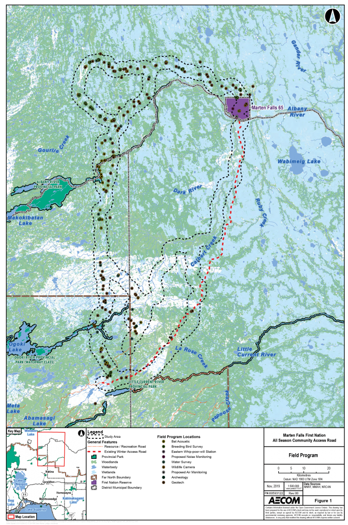
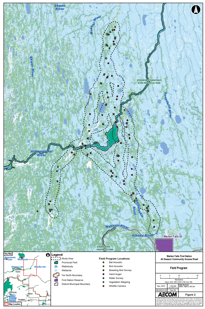
Baseline studies for the Marten Falls Community Access Road Project started before the receipt of an approved Provincial ToR and, the Federal Impact Statement Guidelines – the documents that outline what studies needs to take place during the environmental and impact assessment processes. It is common practice for proponents to begin baseline studies early because multiple field study seasons are often required. The risk in doing studies early is that the regulatory agencies may require additional baseline study work. The risk in not starting early is that the environmental assessment process will take longer. In 2018, Zoetica Environmental Consulting completed baseline studies on moose, caribou and breeding birds. In 2019, AECOM and their subconsultants Dillon Consulting, Golder and, KBM have completed baseline studies that are anticipated to be required by the ToR and Impact Statement Guidelines for the Marten Falls Community Access Road project. In addition to and separate from the environmental and impact assessment processes, AECOM has completed baseline studies along the WaWang’Wajing Road routing options. These baseline studies are being done to support future project planning. The WaWang’Wajing Road would connect the Marten Falls Community Access Road to the mineral rich area known as the Ring of Fire should mineral development happen in the region. Currently, Marten Falls First Nation does not have an agreement or funds to conduct an environmental assessment on the WaWang’Wajing Road. Furthermore, these road development projects are separate and distinct from any mine development projects. A mine developer must complete an environmental assessment and get approval and permits for its mine project before a mine can be constructed even if an all-season road is built. The table on the next page provides a summary of the field work completed for the Marten Falls First Nation Community Access Road in 2019 as part of this project and the anticipated dates of remaining field programs. Figure 1 and Figure 2 provide the locations of each survey. Please reach out with any questions or comments on baseline studies to info@martenfallsaccessroad.ca.
Now Available for Review & Comment
Draft Terms of Reference is available online. To view document, submit comments or, see where hard copies can be viewed, please see our website at:
Deadline to submit comments is January 20, 2020.
Marten Falls Traditional Anishinabek Knowledge
The Community Access Road Project Team and AECOM have been working with the Marten Falls Community Based Land Use Planning (CBLUP) Team to incorporate MFFN Traditional Anishinabek Knowledge (ATK) into the Community Access Road Provincial EA and Federal IA. A subset of the existing digital ATK dataset only covering the Community Access Road project area has been provided to AECOM. No ATK information from the area known as the Ring of Fire has been provided to AECOM.
As part of the ATK program on this project, Bob Baxter and another community member completed site visits with the geotechnical team to ensure valued sites were not disturbed by clear cutting for helicopter pads and drilling work. AECOM was also instructed by the CBLUP team to avoid areas of shared territory with Aroland First Nation until Aroland has a chance to weigh in on whether valued sites exist in areas that will be investigated. Of concern are the Ogoki River crossings at the south end of our project area.
If you wish to provide ATK information for incorporation into the Community Access Road Project, please reach out to the MFFN CBLUP team. The CBLUP team will gladly receive your ATK information and cross-reference with the existing data base to determine if it is new information or, if the values have been previously recorded. If it is new information, the CBLUP will take the appropriate steps to record it following their ATK collection process. We will not solicit or collect ATK during community meetings. Any information we receive voluntarily will be forwarded to the CBLUP team for review before being incorporated into the environmental assessment.
Baseline Scientific Studies & Engineering
Throughout the summer and up until freeze up, AECOM and their subconsultants will be conducting baseline studies, including geotechnical engineering work to characterize the existing environmental conditions. The baseline scientific studies look at the environment from a broad range of scientific disciplines from surveys of air and noise conditions, to existing plants and animal species, species at risk and fish habitat in the project area. Most of these studies do not cause significant disturbance to the environment as they are done by looking and listening. The studies will form the basis for the description of the existing environment in both the provincial environmental assessment and federal impact assessment.
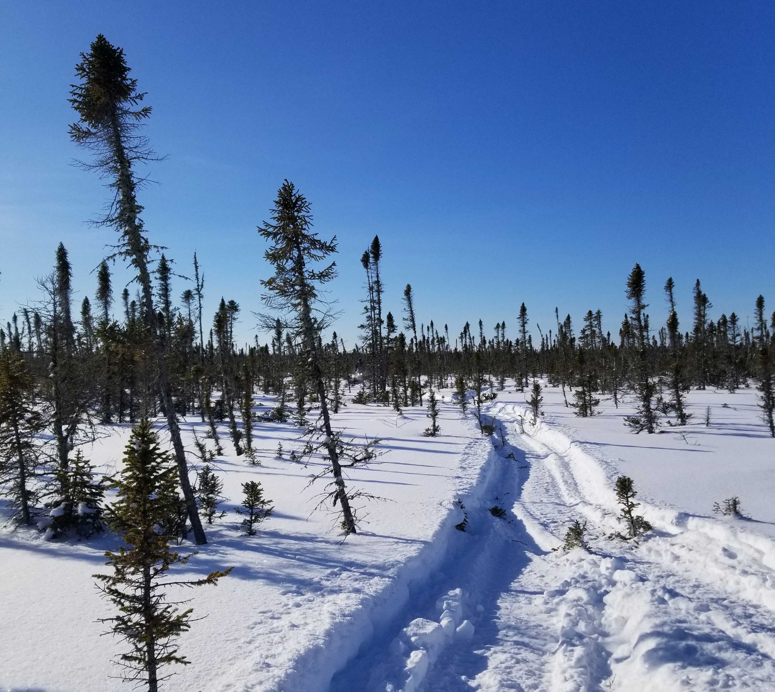
At the same time, engineers have been looking at ground conditions along the identified corridors to locate a road right of way, aggregate resources and develop a preliminary design of the road and structures needed for water crossings. The geotechnical work is an example of a baseline activity that can cause more disturbance to the land. Helicopter landing pads needed to be cleared and hand dug and/or machine drilled boreholes were advanced to assess the depth of muskeg, potential aggregate sources, and to characterize the ground conditions where water crossing structure will be built. In addition, AECOM is planning a value engineering workshop where their engineering specialist will follow a specific process to look at potential costs savings and innovations with the intent of improving the overall design of the road.
Upcoming newsletters will provide more details on the baseline work done and the technical reports being prepared by AECOM. If you have any questions about the baseline study or engineering work, please contact the Community Access Road Project Team and will seek out the appropriate specialist on our team to provide you an answer. You can reach us by email at info@martenfallsaccessroad.ca or by phone at 1-800-764-9114.
Summary of Field Studies
Community Access Road Field Survey Locations
Natural Science
Company: Golder
Dates: June 13 – 17, 2019 and September 2 – 4, 2019
Comments:
- Work executed includes breeding bird counts, incidental wildlife and wildlife camera setup, acoustic recording unit (ARU) set up for bird and bat calls, and high-level data on plant communities.
- 21 wildlife cameras were set up between June 13 and 17, 2019.
- Wildlife cameras were retrieved between September 24 and 26, 2019.
Water
Company: Golder
Dates: September 5 – 10, 2019
Comments:
- Aerial reconnaissance of all water crossings, georeferenced photos were taken, and visual observation were made.
- Ground based surveys at selected waterbody crossings included geomorphic assessment, flow measurements, channel bathymetry, water quality measurements, fish habitat assessment and fish sampling.
Archaeology
Company: AECOM
Dates: September 24 – October 4, 2019, and May 2020 – August 2020 (Tentative)
Comments:
- Stage 1 Archaeological Assessment (AA) flyover field review to determine areas of archaeological interest along the two western alternative routes.
- Based on discussions with the CBLUP Committee, a limited Stage 2 AA survey was completed for the Ogoki River and Albany River in fall 2019. The limited Stage 2 AA physical investigation consisted of test pits and beach surveys at five areas of interest. These areas consisted of two major river crossings (the Albany River and the Ogoki River).
- The remaining Stage 2 AA surveys will commence in late spring 2020.Stage 3 will be required should any cultural material be identified during Stage 2 fieldwork.
Noise
Company: Golder
Dates: November 3 - 6, 2019
Comments:
- Attended baseline noise measurements and unattended monitoring to document existing ambient noise levels prior to implementation of project components.
Air Quality
Company: Dillon
Dates: December 9 – 12, 2019 (Scheduled), February 15 – 19, 2020 (Tentative), and November 15 – 19, 2020 (Tentative)
Comments:
- One year of monitoring to characterize the seasonal variations in ambient air quality (NOx, PM2.5, PM10, TSP, CO, SO2 & BTX). Program to include setup (November, 2019), maintenance (February, 2020), and decommissioning (November, 2020).
Industry Supply Road Field Survey Locations
Natural Science
Company: AECOM
Dates: June 25 – July 12, 2019
Comments:
- Breading bird surveys (acoustic and point count), acoustic bat surveys, wildlife game cameras, incidental observations and Ecological Land Classification and botanical inventories.
- 11 wildlife cameras were set up between June 26 and July 11, 2019.
- Wildlife cameras were retrieved between September 24 and 26, 2019.
Water
Company: KBM
Dates: September 25 – 29, 2019
Comments:
- Aerial reconnaissance and high-resolution photography of route alternatives.
- Ground surveys of 14 sites assessing water courses, fish and fish habitat.